Broadkill River Zone
Click here for a Google Map of launch sites and paddling trails in the Broadkill River Zone. For a Google Map of all launch sites and paddling trails, click here.
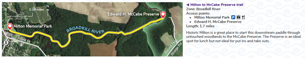
Milton to McCabe Preserve trail
Local information
- Fees & Parking: There is no fee to launch from Milton Memorial Park. Please do not park you vehicle in a space designated for a a vehicle with a boat trailer.
- Tides: The nearest tide tables are for Lewes, Breakwater Harbor.
- Weather: Check the forecast for Milton, DE.
- Trail Towns: Milton
- eBird checklists: McCabe Nature Preserve
- Paddlers’ notes: The recommended paddle is from Milton Memorial Park to the Edward H. McCabe Nature Preserve and back to Milton. There is a floating dock and picnic area at the McCabe Preserve. Please abide by the preserve rules when visiting. For more information about local wildlife and the Milton to McCabe Preserve Trail, please click here.
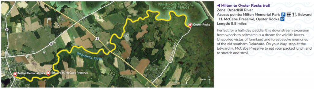
Milton to Oyster Rocks trail
Local information
- Fees & Parking: There is no fee to launch from Milton Memorial Park or Oyster Rocks. Please do not park you vehicle in a space designated for a a vehicle with a boat trailer at Memorial Park. Please park safely along the shoulder near the end of Oyster Rocks Road, but stay on the asphalt (the edges are mostly salt marsh mud, and you can get stuck!).
- Tides: The nearest tide tables are for Lewes, Breakwater Harbor.
- Weather: Check the forecast for Milton, DE.
- Trail Towns: Milton and Lewes
- eBird checklists: McCabe Nature Preserve and Oyster Rocks Road
- Paddlers’ notes: The Broadkill River changes dramatically from Milton to Oyster Rocks. Near Milton, the river meanders through forest before it transitions to farmland and salt marsh towards Oyster Rocks. It is recommended that you paddle with the tide on this trail. During an outgoing tide, depart from Milton. During an incoming tide, depart from Oyster Rocks. If you paddle the full trail, make certain to stop for a break at the Edward H. McCabe Nature Preserve. There is a floating dock and picnic area at the McCabe Preserve. Please abide by the preserve rules when visiting. For more information about local wildlife and the Milton to McCabe Preserve Trail, please click here.
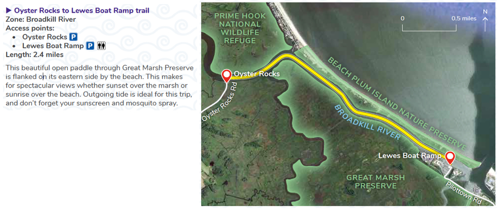
Oyster Rocks to Lewes Boat Ramp trail
Local information
- Fees & Parking: There is no fee to launch from Oyster Rocks or the Lewes Boat Ramp. Please park safely along the shoulder near the end of Oyster Rocks Road, but stay on the asphalt (the edges are mostly salt marsh mud, and you can get stuck!). Please do not park you vehicle in a space designated for a vehicle with a boat trailer at the Lewes Boat Ramp. The launch area can be very busy during peak fishing season (usually April-October), with most traffic in early morning and mid-afternoon.
- Tides: The nearest tide tables are for Lewes, Breakwater Harbor.
- Weather: Check the forecast for Lewes, DE.
- Trail Towns: Lewes
- eBird checklists: Oyster Rocks Road and Roosevelt Inlet
- Paddlers’ notes: It is recommended to paddle on an outgoing tide from Oyster Rocks to Lewes. At the start, the Broadkill River skirts along Prime Hook National Wildlife Refuge before it courses between the Great Marsh Preserve and Beach Plum Island Nature Preserve.