Cape Henlopen Zone
Click here for a Google Map of launch sites and paddling trails in the Cape Henlopen Zone. For a Google Map of all launch sites and paddling trails, click here.
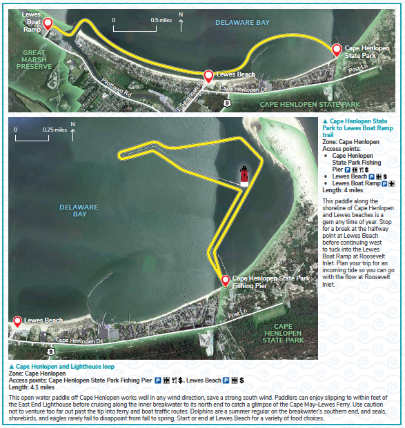
Cape Henlopen State Park to Lewes Boat Ramp trail &
Cape Henlopen and Lighthouse loop
Local information
- Fees & Parking: There is no fee to launch from the Lewes Boat Ramp. Please do not park you vehicle in a space designated for a vehicle with a boat trailer at the Lewes Boat Ramp. The launch area can be very busy during peak fishing season (usually April-October), with most traffic in early morning and mid-afternoon. There is a daily park entry fee for Cape Henlopen State Park, and costs vary for vehicles registered in Delaware and out-of-state. To avoid the daily fee, you can purchase an annual Delaware State Parks pass. If you choose to launch from Lewes Beach, parking meters are in operation seasonally.
- Tides: The nearest tide tables are for Lewes, Breakwater Harbor.
- Weather: Check the forecast for Lewes, DE.
- Trail Towns: Lewes
- eBird checklists: Roosevelt Inlet and Cape Henlopen State Park Fishing Pier
- Paddlers’ notes: It is recommended to paddle on an incoming tide if you paddle from Cape Henlopen State Park to the Lewes Boat Ramp. Please paddle a safe distance around the Cape May-Lewes Ferry Terminal. On your way, you can stop for a beach break at Lewes Beach. For the Cape Henlopen and Lighthouse loop, you can paddle out to the East End Lighthouse and explore life on the rocks along the inner breakwater.